Maps, Trailgauge can use any bitmap
image as a map e.g. scanned paper maps, images from internet
map sites or commercial GIS raster data. Trailgauge can even
generate your own copyright free topographic maps from freely
available height data and your GPS tracks and waypoints. Trailgauge
supports hundreds of map projections and datums. Also automatically
downloads USGS Quads and Aerial Photographs from TerraServer.
Heights, Trailgauge will automatically generate a continuous
and seamless height surface over your map by downloading the
necessary SRTM data which is filitered and interpolated for
your map..
GPS interface, Trailgauge
can download tracks from a Garmin GPS to analyse on your map.
Trailgauge can extract speed data from your tracklogs to give
you a speed graph of your trip including mile or km split times.
After planning your route on Trailgauge simply upload it and
take it with you. Full support for tracklogs, routes and waypoints.
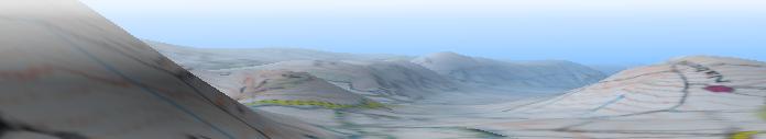
3D Visualization, Trailgauge
allows you to explore your maps terrain in real time on any
OpenGL compatible graphics card. Fly through your routes, or
just explore at random at any altitude. Supports configurable
ground textures, height scaling and distance fogging.
Publishing, Trailgauge renders your routes into high
quality route cards consisting of a map, topographic profile
and list of waypoints directly into HTML for publishing on
the web or printing. more...